

You can find on this page the Long Island transport map to print and to download in PDF. The Long Island transportation map presents the transports network and transport zones of the transit of Long Island in New York - USA.
The Long Island zone map shows all transport zones in Long Island. This zone map of Long Island will allow you to know the prices of public transport of Long Island in New York - USA. The Long Island zones of transports map is downloadable in PDF, printable and free.
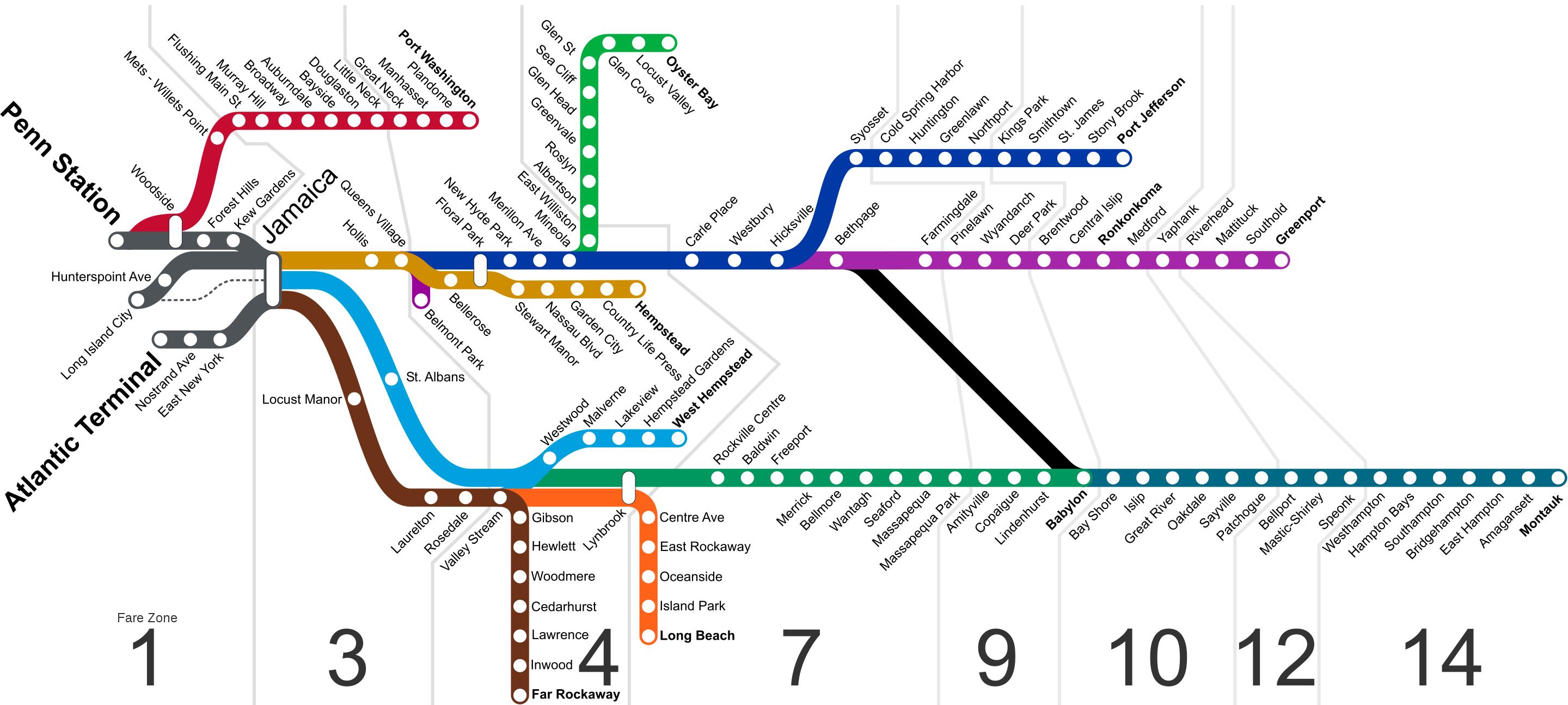
Like Metro-North Railroad and New Jersey Transit, the Long Island Rail Road has a fare system that is based on the distance a passenger travels, as opposed to the New York City Subway which has a flat rate throughout the entire system. The railroad is broken up in to eight numbered fare zones as you can see in Long Island zone map. Zone 1 includes all of the city terminals and stations west of Jamaica. Zone 3 includes Jamaica and all stations east of Jamaica within the boundaries of New York City, except Far Rockaway. Zones 4 and 7 include all the stations in Nassau County and Far Rockaway. Zones 9, 10, 12, and 14 includes all the stations in Suffolk County. Each zone contains many stations, and the same fare applies for travel between any station in the origin zone and any station in the destination zone.
Daily commuters in Long Island can also buy a peak or off-peak ten trip ride, a weekly unlimited or an unlimited monthly pass. Monthly passes are good on any train regardless of the time of day, but are only valid within the fare zones specified on the pass. On weekends the railroad offers a special reduced-fare CityTicket for those passengers who travel within Zones 1 and 3 as its mentioned in Long Island zone map. City Tickets can only be bought from ticket agents or machines. All branches except the Port Washington Branch, passes through Jamaica; the trackage west of Jamaica (except to Port Washington) is known as the City Terminal Zone. The City Terminal Zone includes portions of the Main Line and Atlantic and Montauk Branches as well as the Amtrak-owned East River Tunnels to Penn Station.
The City Terminal Zone as its shown in Long Island zone map is the name given to a collection of rail lines of the Long Island Rail Road in New York City. Specifically, it refers to all stations that lie in Fare Zone 1 (except for Mets–Willets Point on the Port Washington Branch), which are stations west of Jamaica Station. There are four routes that are used within the City Terminal Zone.