
: failed to open stream: Invalid argument in <b>/home/servuzmq/minisites/siteT1/common/template/carteV2.php</b> on line <b>139</b><br />
)
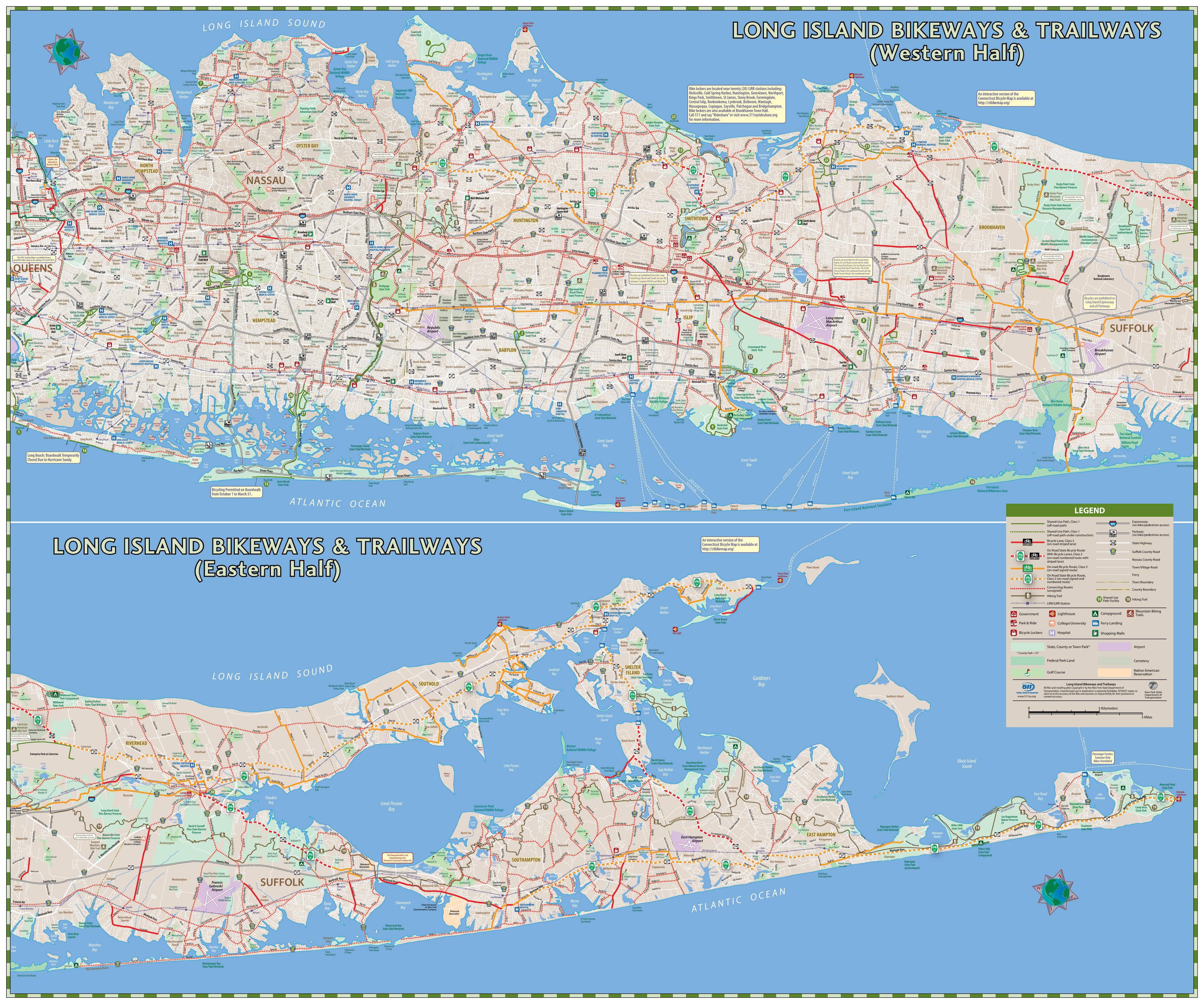
You can find on this page the Long Island bike map to print and to download in PDF. The Long Island bicycle map presents the bike routes and lanes of Long Island in New York - USA.
The Long Island bike lane map shows all the bike routes of Long Island. This bicycles lanes map of Long Island will allow you to easily plan your routes with a bike in Long Island in New York - USA. The Long Island bike lanes map is downloadable in PDF, printable and free.
Bike lanes are shoulders or travel lanes where motorists and bicyclists must respect each others legal rights of a “shared roadway”. While the regional corridor system of State bike routes is intended to provide high quality bicycling facilities, it should not be misconstrued that the mere signage or even bike lane delineation will provide complete protection for all bicyclists. NY 24 State Bike Route as you can see inLong Island bike lane map begins at the Riverhead Traffic Circle and proceeds east through the Pine Barrens and along Peconic Bay on designated bicycle lanes to as far as Old Riverhead Road, just north of Sunrise Highway. NY 25 State Bike Route begins at the intersection of NY Route 25, NY Route 25A and NY Route 111, a half mile east of the Town of Smithtown central business district and it continues northeast along NY Route 25A and then diverts to local roads in St James, Stony Brook and Setauket, and briefly rejoins NY Route 25A in Setauket.
While Long Island does not have many off-road bike lanes, like rail trails, there are many roads that are ideal for cycling, including signed bicycle routes. NY 27 State Bike Route follows NY Route 27 beginning at the intersection of CR 39, east of Southampton Village as its shown in Long Island bike lane map. It continues east along NY Route 27 to the Montauk Point Lighthouse after traversing the communities of Water Mill, Bridgehampton, East Hampton, Amagansett and Montauk. NY 114 State Bike Route runs 15 miles from Greenport to East Hampton. NY 114 State Bike Route connects to NY 25 State Bike Route at Moores Lane, on the west side of the Village of Greenport. NY 114 State Bike Route is unique. Ferry crossings are required at North Ferry and South Ferry as NY 114 State Bike Route crosses tranquil Shelter Island. NY 114 State Bike Route is located on bike lanes between North Haven to Sag Harbor. At Sag Harbor.
The New York State Department of Transportation (NYSDOT), under the Long Island Non Motorized Transportation Study (LINMTS) and in cooperation with local governments, identified a network of local roads that are shown on this map as connecting routes. Connecting bike lanes are mainly on local roads as its mentioned in Long Island bike lane map. Connecting routes are not designated bike routes and have no signs indicating they are a bike route. Connecting routes generally provide a direct connection to the bike network or points of interest including facilities such as parks, beaches, downtowns or train stations. The characteristics of connecting routes vary ranging from low volume roads to facilities carrying significant volumes of traffic that is only suitable for the most experienced cyclists.